

KOKOPELLI RELAY: MOAB TO ST. GEORGE
Course Overview

Course Map and All Legs
Individual Leg Info
*** PLEASE download the official course maps from the link above.
| Transition | Name and Address | Main Route | Estimated Window |
| Start | Grand County High School, Moab | 6:00 a.m. – 7:30 a.m. | |
| 608 Fourth E St, Moab, UT 84532 | |||
| T1 | Wilson Arch | HWY 191 | 7:30 a.m. – 9:00 a.m. |
| US-191, Moab, UT 84532 | |||
| T2 | Monticello Welcome Center | HWY 191 | 9:20 a.m. – 11:20 a.m. |
| 216 S Main St, Monticello, UT 84535 | |||
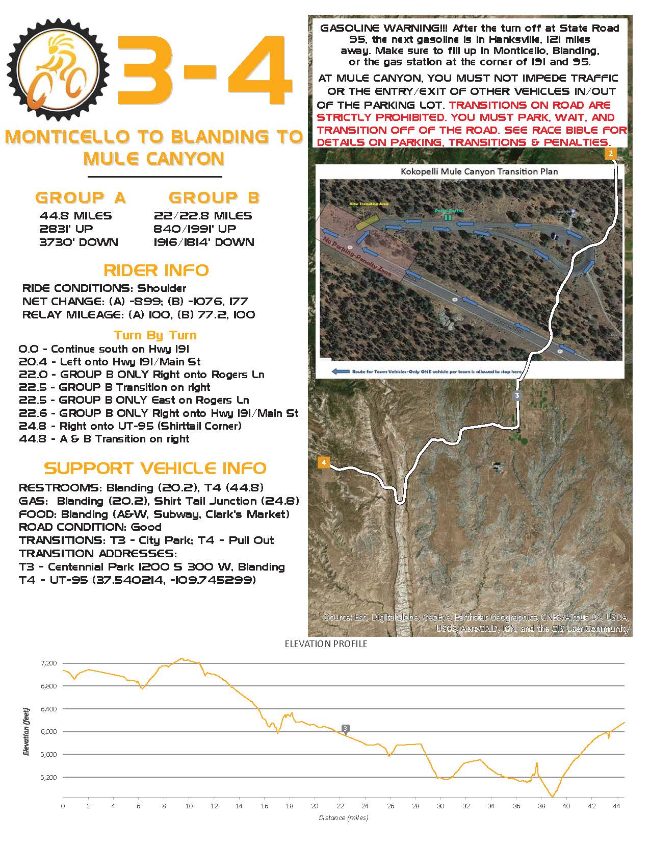
| T3 | Blanding Centennial Park | HWY 191 | 10:20 a.m. – 1:10 p.m. |
| 1200 S 300 W, Blanding, UT 84511 | |||
| T4 | Mule Canyon Road Side Ruins Area | HWY 95 | 11:20 a.m. – 3:00 p.m. |
| Mile marker 101.4, Hwy 95 | |||
| T5 | Shoulder Pull Out WEST (Fry Canyon) | HWY 95 | 12:45 p.m.- 5:15 p.m. |
| 37°38’26.6″110°09’45N.5″W | |||
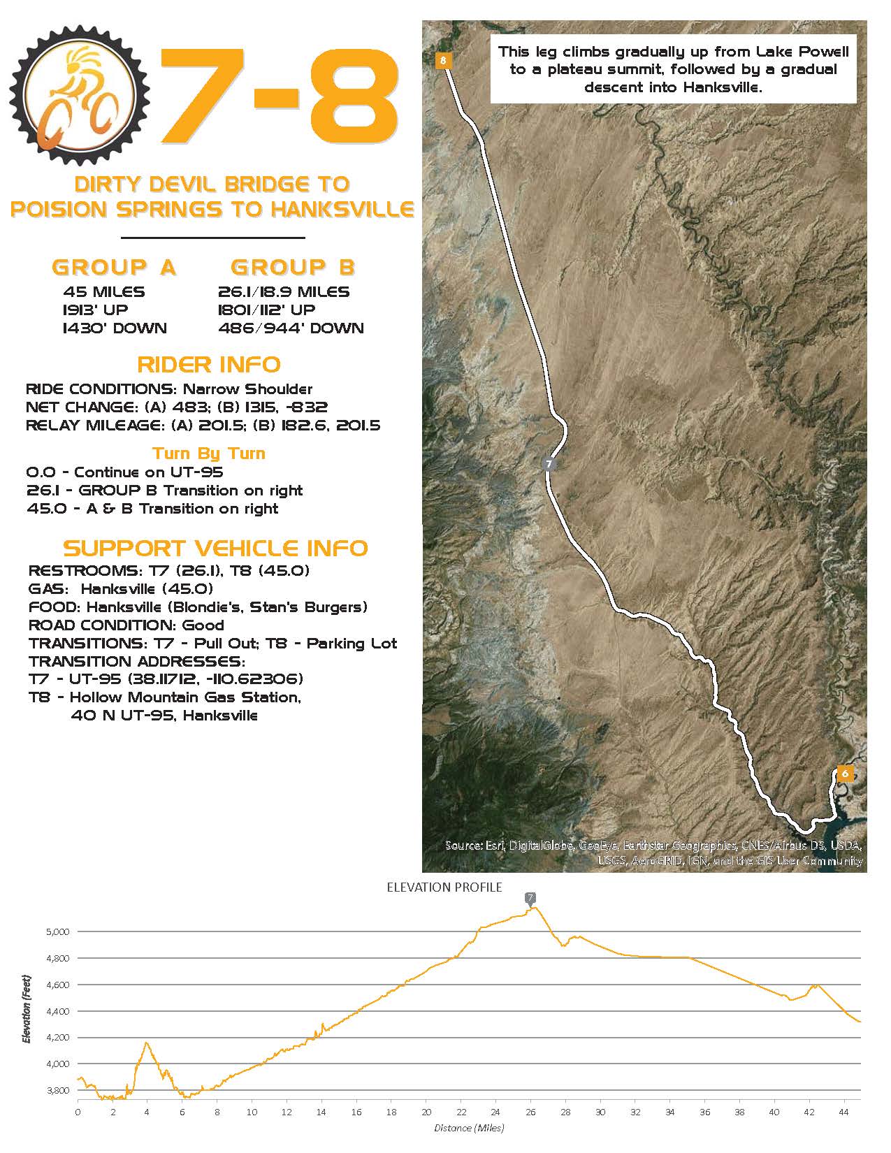
| T6 | Pull Out on EAST past Dirty Devil Bridge | HWY 95 | 2:30 p.m. – 7:30 p.m. |
| .2 Mile Past the Bridge | |||
| T7 | Pull out EAST- 7 miles North of Hwy 276 | HWY 95 | 3:30 p.m. – 8:40 p.m. |
| 38°07’01.6″N 110°37’23.0″W | |||
| T8 | Hollow Mountain Gas Station | HWY 95 & | 4:30 p.m. – 9:50 p.m. |
| 40 N UT-95, Hanksville, UT 84734 | 24 JCT | ||
| T9 | Shoulder Pull out (North Side of Road, East of Notom Bullfrog Basin Rd. | HWY 24 | 5:30 p.m. – 12:00 a.m. |
| 38°17’01.1″N 111°07’40.8″W | |||
| T10 | Torrey (PetroUS Gas Station) | HWY 24 | 6:30 p.m. – 1:15 a.m. |
| 875 UT-24, Torrey, UT 84775 | |||
| T11 | Pleasant Creek Trailhead Parking Lot on UT 12 & FR 247 | HWY 12 | 8:00 p.m. – 2:45 a.m. |
| 38°06’27.8″N 111°20’18.2″W | |||
| T12 | Boulder (Hills & Hollows) | HWY 12 | 9:00 p.m. – 4:00 a.m. |
| 840 UT-12, Boulder, UT 84716 | |||
| T13 | Escalante High School | HWY 12 | 9:50 p.m. – 5:30 a.m. |
| 800 East Hwy 12, Escalante, UT | |||
| T14 | Henrieville Visitor Center | HWY 12 | 11:00 p.m. – 7:30 a.m. |
| 100 West St., Highway 12, Henrieville, UT | |||
| T15 | Pines Rest Area Bryce, UT 84764 | HWY 12 | 12:30 a.m. – 8:50 a.m. |
| 37°42’27.6″N 112°12’20.0″W | |||
| T16 | Panguitch Church Parking Lot | HWY 89 | 1:20 a.m. – 9:50 a.m. |
| 500 S 100 W, Panguitch, UT 84759 | |||
| T17 | Panguitch Lake Church Parking Lot (near General Store) | HWY 143 | 2:00 a.m. – 11:00 a.m. |
| 25 UT-143 Panguitch, UT 84759 | |||
| T18 | FH 050, Duck Creek Village, UT 84762 37°31’06.2″N 112°38’45.1″W | Mammoth Rd | 2:45 a.m. – 12:15 p.m. |
| FH 050 | |||
| T19 | Dirt Pull Out on EAST Right SR 148 | 148 & 14 JCT | 3:30 a.m. – 1:15 p.m. |
| Brian Head, UT 84719 | |||
| 37°34’23.1″N 112°50’11.8″W | |||
| T20 | SUU Shakespeare Festival Parking Lot | HWY 56 | 4:15 a.m. – 2:15 p.m. |
| 300 W Center St, Cedar City, UT 84721 | |||
| T21 | Iron Mountain, Hwy 56 Pull Out | HWY 56 | 5:00 a.m. – 3:30 p.m. |
| 37°36’40.4″N 113°22’57.6″W | |||
| T22 | Enterprise Rodeo Grounds | HWY 18 | 6:00 a.m. – 4:45 p.m. |
| 100 N UT-18, Enterprise, UT 84781 | |||
| T23 | Veyo Bakery & Pies (South End of Lot) | HWY 18 | 7:00 a.m. – 5:45 p.m. |
| 24 S Main St, Veyo, UT 84782 | |||
| Finish | Unity Park, Ivins | 7:40 a.m. – 8:30 p.m. | |
| 200 W 400 S, Ivins, UT 84738 |
The official maps can be downloaded above. The information below is subject to update.

Exchange Details
- Sponsor: TBD
- Mileage Completed: 55.2 miles
- Mileage to Finish: 475.9 miles
Legs 1-2
DO NOT underestimate these legs! These legs do have a lot of climbing, but they are also among the most scenic. Watch for the Hole-in-the-rock at mileage 16 and Wilson arch near mile 26.
Exchange Details
- Sponsor: TBD
- Location: Mule Canyon
- Mileage Completed: 100 miles
- Mileage to Finish: 431.1 miles
Legs 3-4
These legs will take you past the beautiful Abajo (Blue) mountains on the right. Passing thought the Comb Ridge at mile 37.5 is a majestic moment. Leg ends at the Mule Canyon trailhead where Anasazi ruins dating back to 1200 AD can be explored. GASOLINE WARNING!!! After the turn off at State Road 95, the next gasoline is in Hanksville, 121 miles away. Make sure to fill up in Monticello, Blanding, or the gas station at the corner of 191 and 95.

Exchange Details
- Sponsor: TBD
- Location: Dirty Devil Bridge
- Mileage Completed: 156.5 miles
- Mileage to Finish: 374.6 miles
Legs 5-6
These legs offer a nice gradual downhill leading to the Colorado River and beginning of Lake Powell. Pass the Natural Bridges National Monument between miles 17 and 18 where the team vehicle may want to stop for a moment and view some of bridges at the National Monument. Also notice the Jacob’s Chair landmark around mileage 35 on top of the cliffs to the right. As you come to Lake Powell you will cross the Colorado River bridge then immediately after that the Dirty Devil Bridge. Enjoy the beautiful scenery of Lake Powell, but make no mistake -- it gets HOT out here. This is the hottest point in the event, and heat exhaustion is real. Plan on hydrating immediately before and after these legs!
Exchange Details
- Sponsor: TBD
- Location: Hollow Mtn - Sinclair
- Mileage Completed: 201.5 miles
- Mileage to Finish: 329.6 miles
Legs 7-8
These legs have a gradual climb out of Lake Powell up to a plateau summit followed by a gradual descent into Hanksville. Enjoy the view of winding red rock canyons all along the ascent and tall rock pillars and layered cliffs along the descent.
Exchange Details
- Sponsor: TBD
- Location: Sinclair Gas Station
- Mileage Completed: 247 miles
- Mileage to Finish: 284.1 miles
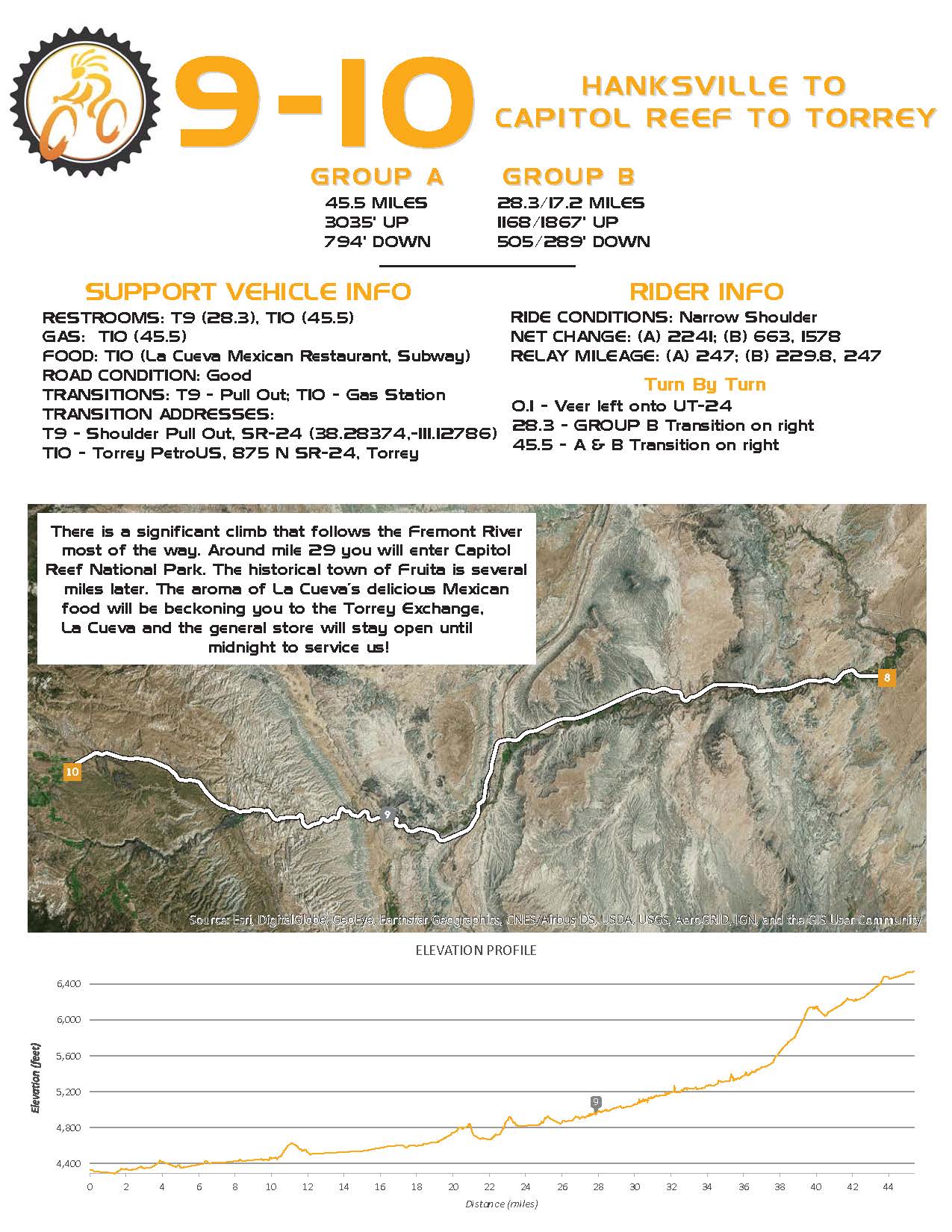
Legs 9-10
These legs boast a significant climb that follows the Fremont River (upstream) most the way. At mileage 29.0 you will enter Capitol Reef National Park. This is park is one of the last great secrets in the USA. As the sun sets in front of you the light will illuminate the towering red cliffs. The historical town of Fruita at mileage 37.4 shows how early settlers of Utah lived. The green fruit trees of Fruita contrast beautifully against the red cliffs overhead.
Exchange Details
- Sponsor: TBD
- Location: Hills and Hollows Sinclair
- Mileage Completed: 286.2 miles
- Mileage to Finish: 244.9 miles
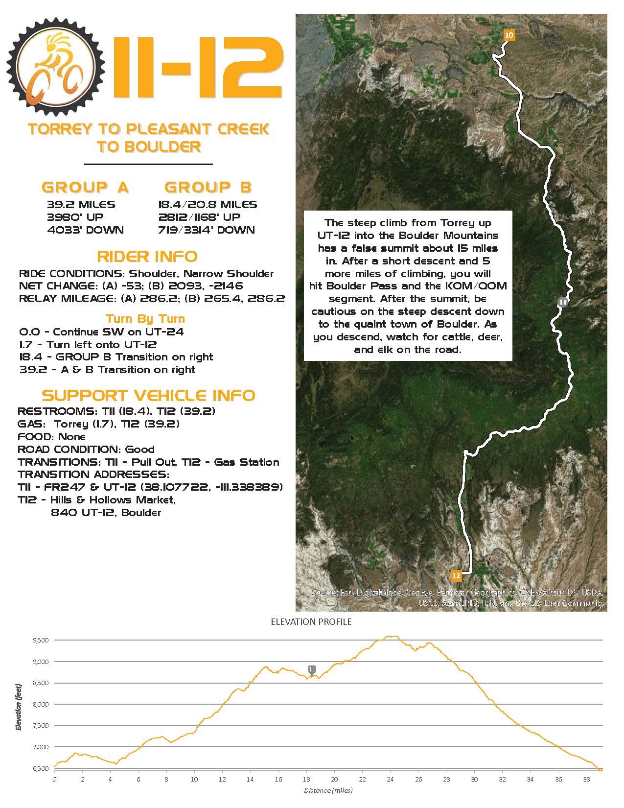
Legs 11-12
From Torrey, pay attention to the quick left turn onto HWY 12 within 2 miles of leaving the previous transition. Start climbing up UT-12 into the Boulder Mountains. Climb is steep up to a false summit at mileage 15 then after a short descent and 5 more miles of climbing you will hit the boulder pass. Take a moment to enjoy the view the east. The mountains seen in the distance are the Henry’s that you just passed earlier in the day. After summit you have a steep descent down to the quaint town of Boulder and to the exchange. Take caution and watch for cattle, deer, and elk on the road during the descent.

Exchange Details
- Sponsor: TBD
- Location: Henrieville City
- Mileage Completed: 342.9 miles
- Mileage to Finish: 188.2 miles
Legs 13-14
This section of State Road 12 is what makes it famous! It just cannot be put into words, but here we go with a meager attempt. As you descend from Boulder down to the Escalante river, you will thoroughly enjoy cycling down the famous ridge at mileage 6.3 with steep drop offs on both sides of the road. You will feel as though you are cycling in the clouds. As you near the Escalante River you will pass the Calf Creek Gorge (home of Calf Creek Falls) on the right. Excellent views from a top the road down to the green bottom of the gorge are breathtaking. Shortly after climbing up from the river on the other side you come to a windy section of road that contours a rugged white slickrock. At mileage 26.1 you will pass through the town of Escalante and begin an ascent back into Dixie national forest. After reaching a mild summit, you wind down the narrow canyon and end in the town Henrieville, population 250. This is a special town, and the residents appreciate it greatly when we do our best not to disturb them. PLEASE BE QUIET!
Exchange Details
- Sponsor: TBD
- Location: Silver Ealge Gas Station
- Mileage Completed: 380.9 miles
- Mileage to Finish: 150.2 miles
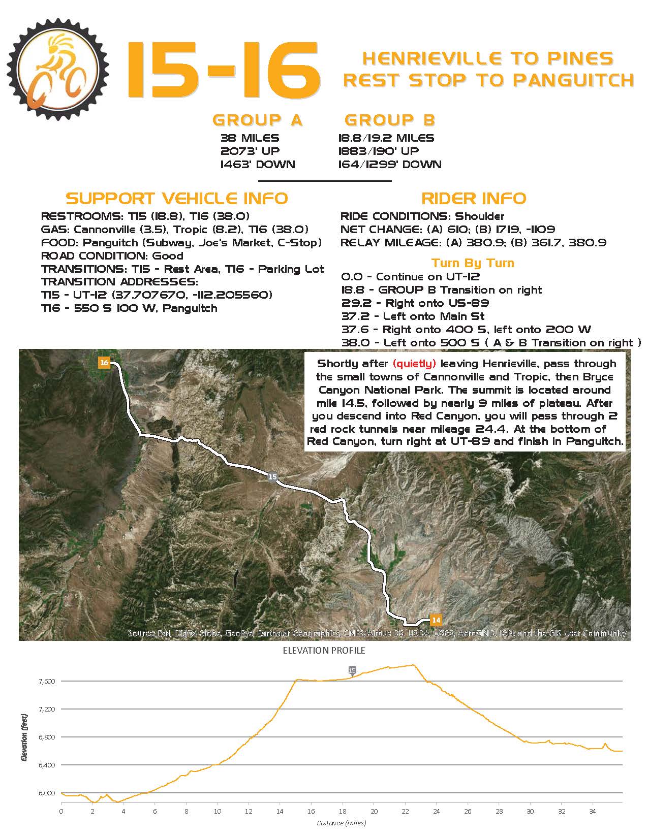
Legs 15-16
Shortly after leaving Henrieville you will pass through the small towns of Cannonville and Tropic. In Cannonville at mileage 3.4 you can find a visitors center for the Grand Staircase-Escalante National Monument. After Tropic enjoy the views to the west of Bryce Canyon National Park from below. At mileage 10.9 you will enter the Park. The road winds up the canyon with spectacular red hoodoos all around. Yes, the official name is a hoodoo. Reach the summit at mileage 14.4 and stay on top the plateau for about 9 miles, then begin the descent into Red Canyon. Again more hoodoos in every direction and pass though the 2 red rock tunnels at mileage 24.4 and 24.5. At the bottom of Red Canyon take a right in UT-89 and finish the leg into Panguitch.
Exchange Details
- Sponsor: TBD
- Location: Duck Creek Rd
- Mileage Completed: 417.3 miles
- Mileage to Finish: 113.8 miles
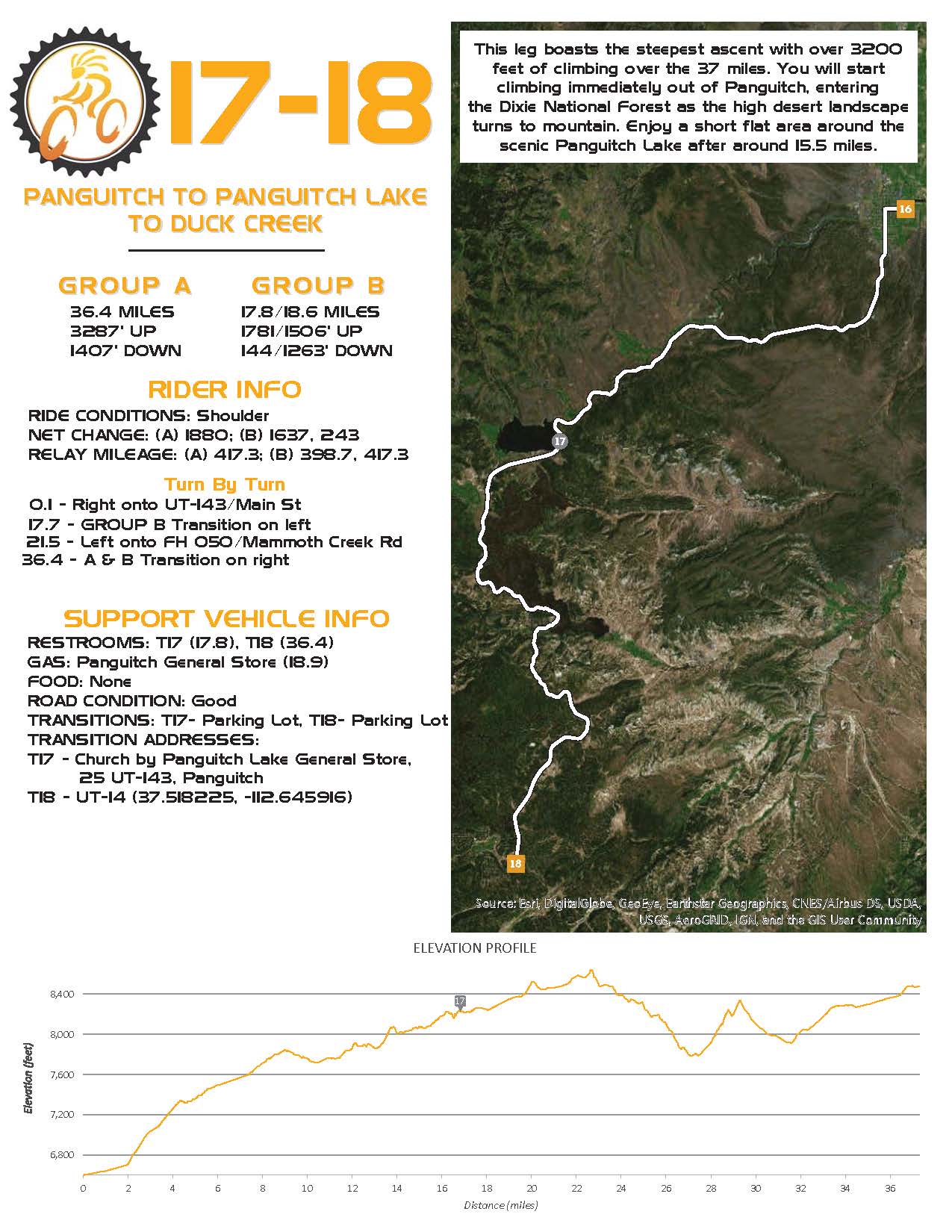
Legs 17-18
This section boasts the steepest ascent with over 3200 feet of climbing over the 37 miles. You will start climbing immediately out of Panguitch, entering the Dixie National Forest as the high desert landscape turns to mountain. Enjoy a short flat area as you bike around the scenic Panguitch Lake at mileage 15.7. After making a left to head to Duck Creek, you’ll have some downhill (and more uphill of course).
Exchange Details
- Sponsor: TBD
Location: Main Street Park
- Mileage Completed: 449 miles
- Mileage to Finish: 82.1 miles
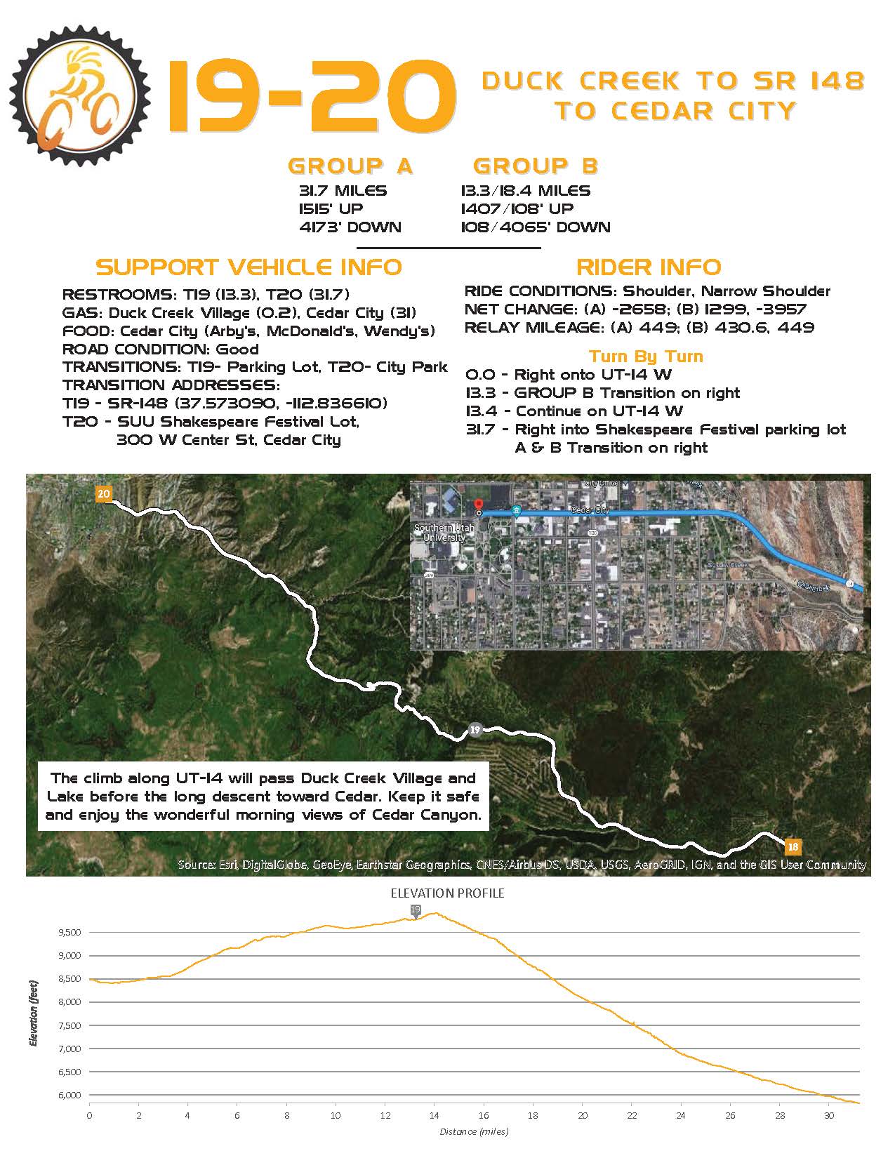
Legs 19-20
Take a right at UT-14 to begin the steep and beautiful descent to Cedar City and exchange location at the SUU Campus.

Exchange Details
- Sponsor: TBD
- Location: Enterprise Rodeo Grounds
- Mileage Completed: 490 miles
- Mileage to Finish: 41.1 miles
Legs 21-22
After leaving Cedar City make the 1,000 foot climb to the Iron Mountain Pass where early Utahns settled in 1850 as part of the “iron mission.” After the pass at mile 30.0 arrive to the tiny town of Newcastle and follow the Bench Road through the ranchlands until you arrive at Enterprise.
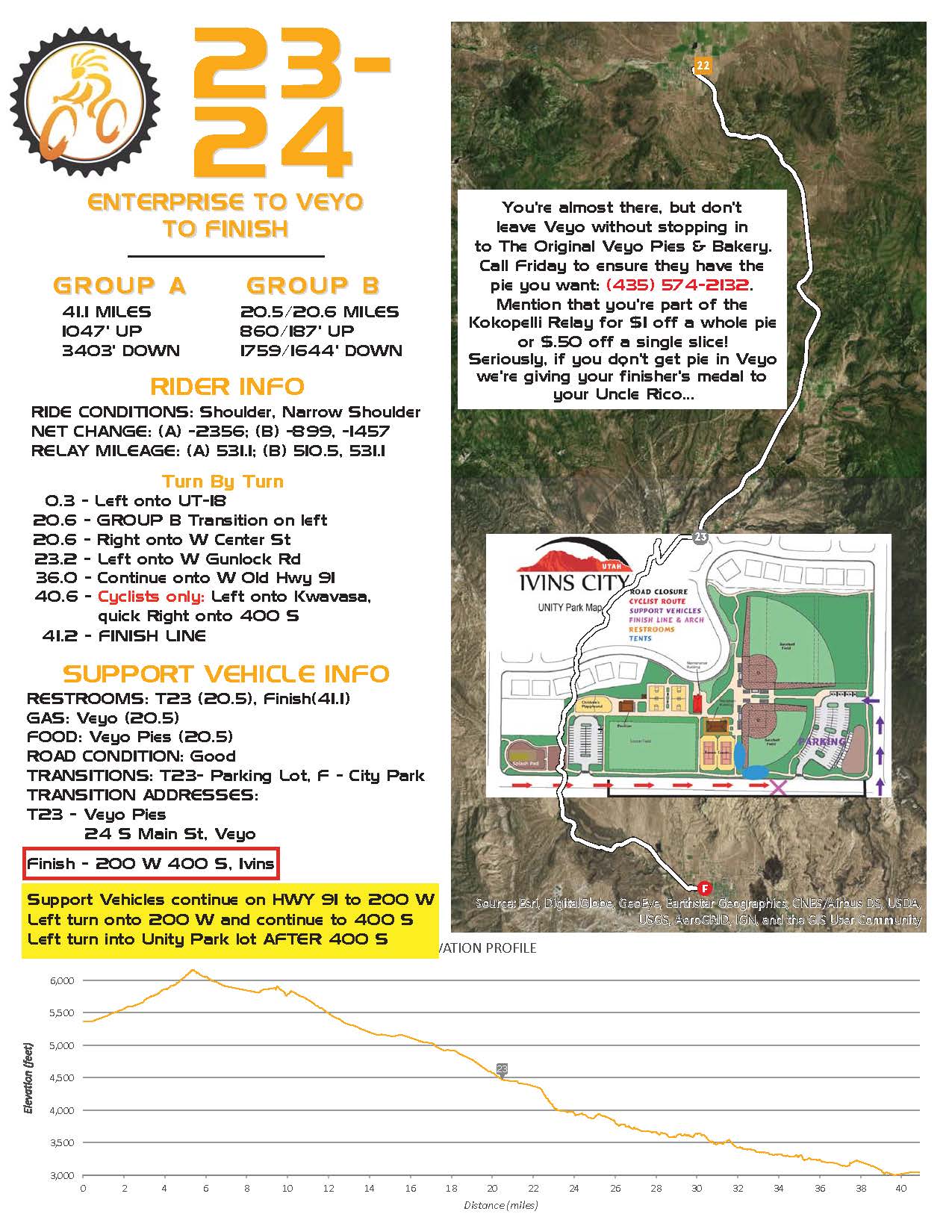
Legs 23-24
What better way to finish the Relay than with a 4,000 foot plus descent into Ivins. Pass through the cedar and juniper-rich mountains south of Enterprise and then descend down through the ancient volcanoes near Veyo and past Gunlock Reservoir. If desired, team members can meet to finish the last mile or two of the course together. Note that the cyclist will turn onto Kwavasa Dr but the support vehicles will continue to 200 W and make a left turn before heading back to Unity Park.
Now, kick back and relax! You have made it and deserve a good rest. The finish line awaits with hydration and goodies!